 |
| Hurricane Patricia, EcoWatch |
***
Early last Friday there was dire news of a category 5 hurricane, named Patricia, that was expected to make landfall in Mexico later in the day. Patricia was reported as the strongest hurricane ever recorded in the western hemisphere. Luckily she struck land in a relatively uninhabited area and her winds had subsided to about 160 miles per hour, as reported by the Washington Post in How Patricia, the strongest hurricane on record, may have miraculously killed so few. Here's a video from GlobalLeak News showing what Patricia and her 160 mph winds looked like.
***
***
Patricia vies with hurricane (aka tropical cyclone) Wilma in the statistics department. However, Wilma traveled further and caused a great deal more damage. This was Wilma's path.
***
 |
| Hurricane Wilma, 2005 track, Wikipedia |
***
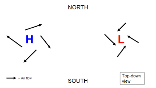
What got me to wondering was "what exactly does a change of 100 millibars air pressure mean?" While I wasn't able to find a direct answer (guess you have to be there), I did find info on how high-low pressure works at WeatherWorks. Here are a couple of diagrams. Note that highs move clockwise and lows, counter-clockwise--at least north of the equator.
***
***
 |
| High-low pressure diagrams, WeatherWorks |
***
With high winds it seems to me the most destructive part is the constant barrage of force prying things apart in small steps. Here's an example of how Wilma worked, published by Tropmet.
***
***
-- Marge


No comments:
Post a Comment